


Thought Leadership
Student Series: Searching for answers on water and sediment formation in the Arctic
This past November, an international team of ocean scientists set sail from Alaska with a mission to better understand water and sediment processes in the western Arctic. Among several research questions, the data they sought would provide answers on how the regional Arctic ecosystem has been impacted by climate change. The expedition was led by Chief Scientist Dr. Robert Pickart from Woods Hole Oceanographic Institution (WHOI). MIT and WHOI have collaborated for over half a century on marine research, and collectively offer a cutting-edge graduate program for marine sciences—the MIT-WHOI Joint Program. Among the twenty-person science team were MIT-WHOI alumni Dr. Pickart PhD ’87 and Dr. Astrid Pacini PhD ’22, as well as a current MIT graduate student, Maaya Prasad ’22, SM ’22.
Breaking the ice
The team worked aboard the R/V Sikuliaq [see-KOO-lee-auk], a research vessel owned by the National Science Foundation (NSF) and operated by the University of Alaska Fairbanks as part of the U.S. academic research fleet. While Arctic Ocean expeditions during the late-fall are rare and therefore valuable, maneuvering through the sea ice can be a challenge. Each day, the team assessed surrounding sea ice formation using radar technologies and created a science operations plan to safely navigate through the space. While the Sikuliaq is an icebreaker rated to break up to 2.5 feet of ice, horsepower constraints and the limited amount of fuel onboard dictated how quickly and effectively the ship could move through the ice. Maintaining lower speeds through thick ice patches resulted in less fuel consumption and ensured enough fuel remained for the return journey.
Winter water formation
The Arctic Ocean is a confluence of Earth’s largest bodies of water, the Pacific and Atlantic oceans. In particular, water from the Pacific Ocean is critical for western Arctic ecosystems. Pacific water trickles through the narrow Bering Strait, a fifty-mile-wide marine gateway that separates Russia and Alaska, to meet saltier Atlantic water in the Arctic Ocean.
The water column is separated into layers based on density, salinity, and temperature. The cold Pacific water covers the top of the warm Atlantic water, trapping heat that would otherwise melt the polar ice cap and aiding in the formation of sea ice. This cold water—also known as winter water—also brings a huge influx of nutrients such as phosphorous and nitrogen to the Arctic. The nutrients are critical for the ecosystem – they spur the growth of phytoplankton, which in turn are consumed by zooplankton swept into the Arctic through Pacific waterways.
Given the importance of Pacific winter water to the Arctic ecosystem, it’s crucial to understand how climate change is impacting these ocean processes. Currently, the formation of winter water south of the Bering Strait is declining and does not form consistently every year. One of the research team’s missions was to document winter water formation north of the Bering Strait in the Beaufort Sea, which is much less well-studied. The timing of the late-season expedition put the team in an ideal position to do so.
Deploying the mooring
The R/V Sikuliaq launched from Nome, a small town on the western Alaskan coast, before steaming across the Arctic Circle towards their first destination—a mooring containing scientific instruments anchored in the Beaufort Sea above Alaska’s northernmost point.
Since 2002, scientists have maintained a mooring in the Beaufort Sea north of Point Barrow to document the flow of Pacific water entering the Arctic Ocean. For the past 20 years, scientists have gained a unique, long-time view of Arctic processes as the climate warms.
Scientific moorings are tethered to the seafloor using a heavy anchor. They contain communications systems and a variety of marine sensors below the waterline. The mooring was placed near the Beaufort Sea shelf break, where the seafloor suddenly slopes toward the deep basin and where a jet of Pacific-origin water is found. The instruments measure water and ice velocity, ice thickness, temperature, salt content, chlorophyll, nitrate, as well as the presence of zooplankton and marine mammals.
The team’s first goal was to service the mooring. Due to the late season, sea ice had already formed in the Beaufort Sea. Over the course of two days, the team successfully freed the mooring from beneath the ice, recovered the data, and redeployed the mooring to continue data collection.
Water and sediment sampling
The expedition then shifted focus to performing a large-scale survey of the western Arctic. The data collected would not only continue to inform scientists on winter water formation but would also answer questions on how climate change is impacting other aspects of the Arctic ecosystem.
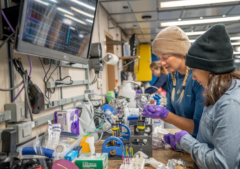
The primary instrument used was a CTD, which electronically measures conductivity (salinity), temperature, and depth as it is lowered to the seafloor. The CTD is mounted on a package that also collects water samples at different depths for measuring other properties such as nutrients and carbon. With this data, researchers can track the distance and depth that Pacific water travels throughout the western Arctic.
Once at sea, the team chose areas to conduct CTD casts by combining known areas of scientific interest with satellite ice imagery. Each marked area, known as a transect, would take roughly 20 hours to occupy while conducting continuous science operations. On deck operations took place in a variety of conditions, ranging from rolling ten-foot waves in the Chukchi Sea to subzero temperatures in the sea ice. Further delays were introduced depending on ice formation. In certain regions, the ship moved at an average speed of 5 mph through the ice. Occasionally, a berth of ice wider than the ship would need to be broken so instruments could be placed in the water. The CTD was deployed an average of 15 times per transect leg.
After the mooring was redeployed, the team continued east to the Mackenzie River Delta where they were stopped by thicker than expected sea ice. Instead of journeying farther east, the researchers slowly steamed back along the north Alaskan coast while conducting data collection transects. The CTD was deployed over a hundred times through the building sea ice.
Several ancillary projects took place on the ship. For one such project, water samples were also tested for the presence of harmful algal blooms (HABs), which produce toxins that can cause illness and death in humans and wildlife. These algae can also form cysts that live on the seafloor. In warmer conditions, dormant cysts germinate, resulting in algal blooms at the sea surface. With climate change causing rising seafloor temperatures, HABs are becoming an increasing threat to Arctic Alaskan residents. To monitor the presence of these cysts, the researchers also collected surface sediment and invertebrates that consume the cysts (such as clams and worms) on transect legs.
In addition to surface sediments, researchers also collected sediment cores to determine how sea ice formation along the Northern coast of Alaska has been impacted by climate changes over the past ten thousand years. These changes can be determined by analyzing molecules produced by bacteria dwelling in sea ice. These molecules eventually settle onto the seafloor and are buried and preserved within the sediment. Cores are cylindrical sediment samples that can be several meters long and are collected by inserting tubes into the seafloor. The longer the core, the older the historical record. Cores collected on this trip were up to 6 meters long, and will give researchers an understanding of various geological processes stretching across thousands of years, including insight into how the sea ice has reacted to both recent and past climate changes.
A successful cruise
After a month at sea, researchers headed back to the R/V Sikuliaq’s home port in Seward loaded with data samples that will help shine a light on how the Arctic is reacting to a changing climate. While some scientists obtained preliminary results onboard, other collected datasets may take years to process. This cruise was Sikuliaq’s last Arctic cruise of the season, and the ship will return to Alaska in early spring to continue bringing researchers across the Arctic circle.
In the Iñupiaq language, the word for young sea ice is Sikuliaq, a name fitting for this research team’s science mission. Dr. Astrid Pacini agreed. “This cruise provided us with the unique opportunity to sample the freeze-up period,” she said. “We are returning to port with fascinating open questions, beautiful datasets, and sincere gratitude for the time spent underway.”