


Data-Driven Flood Risk Planning
MITOS, along with fellows and researcher scientists, engages climate modelers, scientists, and engineers at MIT and in Cambridge and Boston to help inform data-driven flood risk planning for the campus and region. Explore MIT's Climate Resiliency Dashboard.
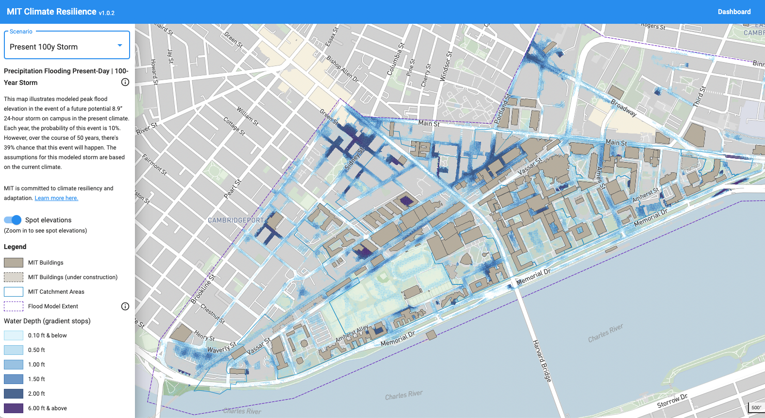
The MIT Climate Resiliency Dashboard is an informational tool enabling the MIT community to understand risk to the Cambridge campus from flooding under both today's climate a future, changed climate. Learn more about the Dashboard in a recent MIT News article. This dashboard seeks to translate the science of these climate risks into visual maps for use in operational and strategic decision-making about campus-wide planning, capital renewal, new capital projects, and community preparedness. This Dashboard has been created using the latest climate impact models (in partnership with the MIT Center for Global Change Science) and is harmonized and regularly updated with the City of Cambridge's climate change flood model. Read more here.
MIT Campus Flood Risk Model:
Informed by both the MIT Flood Vulnerability Study and Sustainability Stormwater and Landscape Ecology Plan, MIT is preparing a campus-based flood risk model that will integrate campus risk modelling with the City of Cambridge Flood Risk Model. This combined model will provide a comprehensive understanding of current and future risks to a range of flood scenarios including precipitation, riverine, sea level rise and storm surge events. Since MIT is also undergoing a significant capital renewal, this dynamic two-dimensional model will also serve as an adaptive planning tool for informing current and future flood risk based on new campus growth.
MIT Flood Vulnerability Study Phase - 1A Report: This report served as a key scientific justification for development of the MIT campus flood risk model. This report summarizes findings from the initial research study to understand the general scope and extent of flood risks facing the MIT campus in both the current and future climate. This paper was prepared jointly between MITOS and the Joint Program on the Science and Policy. Read the paper here.

MIT Stormwater and Landscape Ecology Plan: MIT completed the Phase 1 Draft Stormwater and Landscape Ecology Master Plan (2017) that provides an overview of stormwater management challenges at both a campus and city-scale context, recommends benchmarks for landscape performance and identifies potential strategies for enhancing campus management of stormwater and landscape ecology. Read the plan here.